
Venice Districts & Attractions – Introduction.
Venice Districts & Attractions – Introduction. Discover Venice with the my comprehensive guides to all six sestieri and main attractions.
These ancient administrative divisions, date back to the 12th century and still today remain central to the city’s identity and magic. Each sestiere offers a unique blend of history, architecture, and atmosphere, making Venice a mosaic of experiences waiting to be explored.
Each sestiere contributes to Venice’s timeless allure, offering a different lens through which to experience the city’s magic.
This Introduction to Venice’s Disticts and Attractions and its six associated posts, will help plan your visit and increase your enjoyment and appreciation of this wonderful aquatic city.
- General Introduction
- The Six Districts or Sestierila
- My “Introduction to Venice” Post
- Comprehensive Links (internal–external)
General Introduction
Venice (Venetian: Venexia, Italian: Venezia, Latin: Venetia) is the capital of the region of Veneto.
The name Venice is derived from the ancient Veneti people, who inhabited the region by the 10th century BC. The city was historically the capital of the Republic of Venice and has been known as the “Serenissima”, “La Dominante”, “Queen of the Adriatic”, “City of Water”, “City of Masks”, “City of Bridges”, “The Floating City”, and the “City of Canals.”
The city stretches across approximately 118 small islands in the marshy Venetian Lagoon along the Adriatic Sea in northeast Italy. The saltwater lagoon approximately 50 km in length, stretches along the shoreline between the mouths of the Po (south) and the Piave (north) rivers.
The city is mostly 1 m above sea-level; buildings are supported on millions of poles driven into the sediment, made predominantly from alder wood. Over 160 canals are spanned by more than 600 bridges.
Canals are flushed out by tides that sweep in from the Adriatic Sea, through three channels that pierce the ring of sand bars or “lidi” protecting the lagoon.

A typical scene from one of the three parallel canals in the wonderful district of Cannaregio
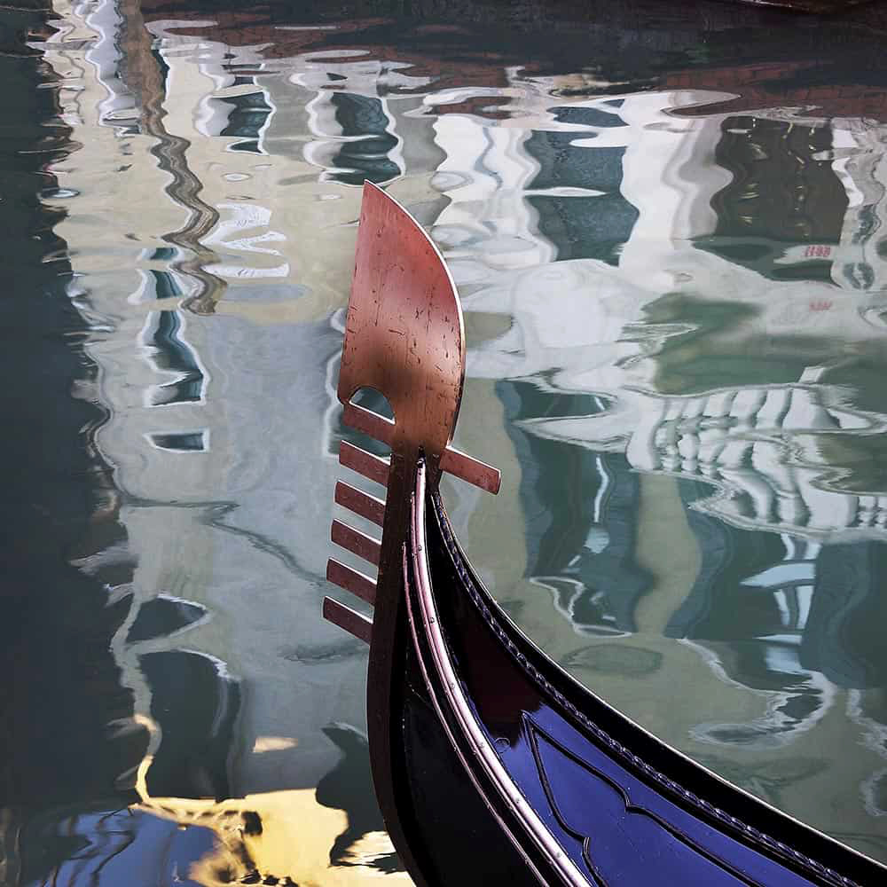
Interestingly, the stylized representation of the Six Districts of Venice, can also be seen on one of the most important and iconic symbols of the city – the raised iron prow of the Gondola:
- The 6 front teeth (6 sestieri)
- The back tooth, the symbol of Giudecca
- The S-shape reminiscent of the sinuous path of the Grand Canal
- The small arch reminiscent of the Rialto Bridge
- The upper volute is reminiscent of both the Bacino San Marco and the “Dogal Horn” (doge’s headdress)
Venice Districts & Attractions – Introduction Venice Districts & Attractions – Introduction Venice Districts & Attractions – Introduction
Venice Districts & Attractions – The Six Sestieri.
Venice has six districts or “sestieri” namely: San Marco (including San Giorgio Maggiori), San Polo, Santa Croce, Cannaregio, Dorsoduro (including the Guidecca and Isola Sacca Fisola) and Castello (including San Pietro di Castello and Sant’Elena).

Sestiere is derived from the word sesto (a sixth) and is thus used for towns divided into six districts. Each district was administered by a procurator and his staff. Nowadays, each district is a statistical and historical area, without any degree of autonomy. As mentioned above, the six fingers or phalanges of the “ferro” on the bow of a gondola represent the six districts.
The districts consist of parishes, initially seventy in 1033, but reduced under Napoleon and now numbering thirty-eight. These parishes predate the sestieri, which were created in about 1170.
Each parish exhibited unique characteristics, but also belonged to an integrated network. The community chose its own patron saint, staged its own festivals, congregated around its own market centre, constructed its own bell towers and developed its own customs.
Other islands of the Venetian Lagoon do not form part of any of the sestieri, having historically enjoyed a considerable degree of autonomy.
Each sestiere has its own house numbering system. Each house has a unique number in the district, from one to several thousand, generally numbered from one corner of the area to another, but not usually in a readily understandable manner.
Although there are six districts, it is possible to cross the city on foot in under an hour and indeed it is often quicker to walk than catch a water bus.
Venice Districts & Attractions – Introduction Venice Districts & Attractions – Introduction Venice Districts & Attractions – Introduction
The zones do not really have strict divisions, but they are characterised in different ways, often not particularly obvious to the casual visitor. This is especially true today of the San Polo and Santa Croce districts, which appear to merge together. Links to each individual district posts are found below:
San Marco – The Heart of Venice
- San Marco is the historic and symbolic heart of Venice; originally the seat of government and religious centre. It functions today, as Venice’s principal tourist, institutional and ceremonial centre.
- Although geographically small, it concentrates the city’s most famous monuments and iconic landmarks, such as: St. Mark’s Basilica, the Doge’s Palace, and Piazza San Marco.
- A bustling hub of tourism, luxury shopping, and historic cafés.
- Rich in cultural heritage, with frequent events and exhibitions.
Cannaregio – Tradition and Tranquility
- The most populous sestiere, known for its quiet residential charm and also the historic Jewish Ghetto, the beautiful Ca’ d’Oro, and the Chiesa della Madonna dell’Orto.
- Includes the Santa Lucia train station, making it a gateway to the city. It is linked to the Rialto commercial centre by the Strada Nova in the south of the district.
- Offers authentic Venetian life with canal-side osterias and local shops.
Castello – From Palaces to Public Gardens
- Castello is the largest and most varied sestiere, running from the tourist spine near St. Mark’s to the quieter eastern shore and the Giardini; it contains the Arsenale, the Giardini della Biennale, important churches such as Santi Giovanni e Paolo, and long stretches of waterfront life on the Riva degli Schiavoni
- .Features the Giardini della Biennale, a lush park hosting the Venice Biennale art exhibition.
- A mix of grand architecture and working-class roots, with many working-class tradespeople originally employed in the Arsenale.
Dorsoduro – Artistic and Academic Vibes
- Dorsoduro occupies the southwestern edge of Venice, includes the highest ground in the central islands and the islands of Giudecca and San Giorgio Maggiore, and is known for its artistic and student energy.
- Gallerie dell’Accademia, the Peggy Guggenheim Collection, Ca’ Rezzonico, the Zattere promenade and lively Campo Santa Margherita define its relaxed, creative character.
- Popular with students due to the nearby Ca’ Foscari University.
- Offers stunning sunset views from the Zattere promenade.
San Polo – Markets and Medieval Charm
- San Polo is the smallest sestiere by area, but one of the most intense culturally and commercial.
- Centred on Campo San Polo and the Rialto quarter; it hosts the Rialto Bridge, the historic fish and produce markets, the Scuola Grande di San Rocco and the great Basilica dei Frari, giving it a compact mix of trade, craft workshops, and dense medieval streets.
- A great spot for traditional Venetian cuisine.
Santa Croce – Gateway and Hidden Gems
- Santa Croce sits at Venice’s northwest corner and includes Piazzale Roma, the city’s main bus terminal and car access point.
- Beyond the transport hub lies a quieter, very Venetian quarter with Campo San Giacomo dell’Orio, Ca’ Pesaro (Museum of Modern Art), and a series of local squares and canals that feel residential and understated compared with the more famous sestieri
- Ideal for those seeking a more local, off-the-beaten-path experience.
My “Introduction to Venice” Post
Linked below, it is a great starting point to develop your understanding and enjoyment of this historic city and its lagoon environment. If you are planning a trip, or on limited time once there; this “all-in-one”post will maximise your appreciation and enjoyment of this unique aquatic city.
I have included the content headings, to let you see how comprehensive this guide really is:
- Brief History
- The Veneto (“Venezia Euganea”)
- The Metropolitan City of Venice
- The Historic Island City (“Centro Storico”)
- Districts and Parishes
- House numbering system
- Origin of the Name.
- The Language of Venice
- The Climate of Venice
- Venetian Wells – The Source of Drinking Water
- Traditional food and drink of Venice and the Veneto
- Flooding and Subsidence, Pollution and Algal Growth.
- Acqua Alta and the MOSE Project.
- Architecture, Art and Music
- Places named after Venice
- World-wide Venetian style Campaniles
- Links Section to all my 200+ posts and for convenience, a selection of posts to get you started and on your way to be a Venice expert!
Venice Districts & Attractions – Introduction Venice Districts & Attractions – Introduction Venice Districts & Attractions – Introduction
Links (internal–external)
Please click on the links below, to see my other six comprehensive “Districts and Attractions” posts:
San Marco: District and Attractions
Castello: District and Attractions
Dorsoduro: District and Attractions
Cannaregio: District and Attractions
San Polo: District and Attractions
San Croce: District and Attractions
Introduction to Venice A great starting point to develop your understanding and enjoyment of this historic city and its lagoon environment. If you are planning a trip, or on limited time once there; this post will maximise your appreciation and enjoyment of this unique aquatic city.
St Mark’s Square Guide This unique all-in-one post, will give you everything you need to know about the most famous square in Venice. Three suggested walk’s, starting from St Mark’s Square are included; together with links direct to the main attractions, tourist board offices and other ticketing agencies, discount cards and much more.
Best High Views in Venice Campaniles and roof-top terraces and restaurants, offer new perspectives on the city; as well as a truly memorable experience.
Two Great Walking tours of Venice’s Public and Private Art Gallery Scene:
Private Art Galleries of San Marco
Posts for Getting Around – Basic Terminology – Discount Cards and Passes
Getting Around – Basic Terminology
Venice Discount Cards and Passes
(3152) Venice Vacation Travel Guide | Expedia – YouTube
Venice Districts & Attractions – Introduction Venice Districts & Attractions – Introduction Venice Districts & Attractions – Introduction